After two great weeks on Vancouver Island, we arrived back in Squamish on the 27th. After catching an early ferry across, and running a few errands in Vancouver, we were back in town with enough time to do some late afternoon climbing. We were happy to find that none of the things that were left in the tent went missing while we were away, and there was not a large family of raccoons living in there, as my brother suggested there might be!
Since getting back we've been trying to push up the grades that we are climbing at. So far that has been going well; most notably, yesterday evening Ashley onsighted (climbed to the top, on the first try, without sitting on the rope or pulling on any gear) a climb called "The Zip". This is a classic Squamish climb at the grade of 5.10a. Earlier that day I managed to work my way up a 5.10b climb called "Slap and Tickle", also an onsight.
Other than that it's pretty much back to the normal routine. It is still really hot here, and our campsite in the shade makes sleeping in far too easy.
Ashley grinding her way up a short squeeze chimney.
The leopard spots are coming back! It took me a while to figure out where these were coming from; they are Camelot bruises from where my gear bumps or get pressed against my thigh while climbing. Ah, its good to be back in Squamish!
When we first were planning our trip to Strathcona Park we thought that we may be able to climb a few peaks in the 4 days that we had in the area.We had been scouring over the “Island Alpine” guidebook and decided to start up the Elk River Trail for the first few days and set up a base camp from which we could explore the surrounding peaks.We had heard that the conditions were unusually snowy still for this time of the year but even with that considered there seemed to be more things to do then we could possibly tackle in one trip.
As we were getting ready to set off we quickly realized that we hadn’t really planned for backpacking/serious mountaineering when we left Calgary in June; we only brought small day packs, a Canadian Tire two man tent and Paul’s sleeping bag couldn’t pack down into a manageable size.We had solved the issues of only having a single pair of crampons, one ice axe and my mountaineering boots badly needing to be replaced in our little excursion to Vancouver, but it would have been unreasonable/ expensive to buy the backpacking gear we already owned.We would make do with what we had.
With 3 packs between the two of us, gear hanging off and sticking out of our daypacks in an unruly manner and wearing climbing harnesses, we must have looked like a pair of crazies (or novices) when we started up the trail. We had rock gear, ice/snow gear, camping gear, and 2.5 days worth of food, our Island Alpine bible, a map and various clothing layers and our standard first aid & emergency kits.We were totally oblivastoked. At about the 2km mark on the Elk River Trail we branched off, crossed a raging river via log-jam and put our faith in to the vibrant flagging tape to lead us through the brush. The goal for the day was a campsite on the North West ridge of Mt. Elkhorn that the book described as “nice, with a good view and water”.What more could we ask for?
3800ft of elevation gain in 6000ft of horizontal travel and 8 hours later, we poured over the map in our tent in the NW ridge of Elkhorn awakened to the reality that this mountain was much bigger (and steeper) than the book had made it seem; We had known we were in for a solid hike but we hadn’t expected vertical tree root climbing, soggy fixed ropes over seeping mossy rock walls and sections of “hiking” that had us gaining a foot of elevation for every two feet traveled.It was a hell of a grind.
Base camp with a the summit of Elkhorn (pointy and slightly left leaning) peaking out behind first of the 3 smaller crests that we would have to go over to get to it.
The photo from the book showing the NW ridge route. This is only about half of what we still had left to do from base camp.
We had another 3320ft of elevation still to gain, the water at the campsite was either a snow pile or the slum puddle from the snow pile melt-off, and we had much more technical terrain ahead of us. We decided that we needed scout the route, check out the avalanche danger and see if we were in over our heads. This would mean an additional day and a half on the mountain if decided we could do it, and therefore we would have to do some serious food rationing and snow-melting to get us through.
Our scouting mission, our first encounter with snow!
This is taken 30min out of base camp at about 5000ft. Out of curiosity we surfed the net and found photos from other peoples trips up this route and this section is a snow-free boulder field.
Paul pondering the feasibility of reaching the summit.
At the end of our scouting mission, after meandering our way over snow fields that hid both our trail and trail markers and taking a look at the mountain we decided that we shouldn’t do it; too much snow (and therefore a potential avalanche risk in the 30 degree heat), we only brought a 20m rope, and it would be hard to make the food thing work.
However, come the morning of day three we just couldn’t walk away, the summit called us and so at 10am we decided to “go take a look” ...just to see if it would go.
A snow arch framing part of the sun-cupped Elkhorn Glacier
Looking out to the snow-capped mainland peaks visible along the horizon from the col. We are only another 20min to the start of the climbing section.
The final push. The route we took is the right leaning line that you can see over Paul's right shoulder, then we traversed leftward to the upper glacier where it wraps itself around a tower.
This photo gives a bit of a better perspective.
Once we got to the upper glacier we crawled into the bergschrund (the gap between the glacier and the rock face). We followed its path around the rock tower till the gap became too small and we were forced to climb the rock (with some aid from the snow) to gain higher ground. After a bit of rock traversing we got to rappel back into an even deeper (4-5m) section of the bergschrund and finally exit out onto the final section of scrambling.
5:30pm and we were on the summit.Turns out it wasn’t bad as we thought it might be- we could easily navigate around any sections that we were unsure about, the snow pack was solid (though there was lots of it) and the climbing was a breeze even with a short rope.It was some of the most interesting mountaineering terrain that we could get all in one package and the view from the summit was amazing!!!Sadly, there is no rest for the wicked and after a peanut butter and honey warp and a look around we descended via the West couloir down a steep snow field to regain the NW ridge and retrace our steps to our base camp by 9:30pm.
We are so glad that we decided to “go take a look”, it was a great experience!We’ve both learnt a lot and are really excited to try some of the other mountains in the area when we can make it back this way.
Back in Nanaimo, we have a day to kill before we can catch the cheaper ferry back to the mainland.It will be nice to take it easy!
We have had a wonderful past few days. It is truly beautiful out on the west coast of Vancouver Island! However, its also colder than we have become accustom too since the mid-thirties weather in Squamish... toques, down jackets and fuzzy socks are all requirements for most of the day and especially at night. That hasn't gotten us down though; we've still been hiking, checking out the local beaches and even doing a little surfing!
We met up with Bonnie and her Padres two days ago and took in the sights between Ucluelet and Tofino looking for a good hike, eventually find the pleasant jaunt down to Halfmoon Bay. Yesterday we decided to try out the "Wild Pacific Trail" that turned out to be less wild and more of a tour through the developing commercial yuppie residential zone. Nice once you were far enough way from houses or bulldozed lots, but not what we were expecting from the name. Then we rented some surfboards and wet suites, picked up Bonnie and were off to Wick beach for some evening surfing. Paul did great for his first time out and didnt get pummeled too terribly. Surfing is definitely one of those sports that take tons of practice and is way harder then it seems.
We were at it again this morning, both of us doing better than we were last night and even got to enjoy some sunshine while we got thrashed about. Now were back in Nanaimo trying to figure out a course of action from here. Sounds like to get the equipment we need for some mountaineering we want to do in Strathcona Park we are going to have to ferry back to Vancouver, go to MEC and then ferry back here tomorrow.... bummer.
However! After all of that is done we should set for a wickedly awesome expedition into the heart of the island mountains to bag a few peaks, get our resumes in and even do some alpine climbing. Should be awesome!
Checking out the abundant fauna in the tidal pools with Bonnie and her parents
It was so great to see Bonnie again!
Wick beach this morning. It was starting to get hot out and the water was evaporating of the sand creating a beautiful mist that hung just a few feet of the sand.
Unfortunately, surfing (or swallowing sea water?) seems to make Paul feel nauseous so after a few hours he turned in his board for his camera and snapped all of these shots!
Riding a wave in!
Peace, Love, Anarchy and Surfing (....and climbing)
Paul doing the dishes in our Ucluelet kitchen.
Staying warm! We were really suprised that we had to dig out all of our layers from the depths of the car. Misty and cool.
Since we arrived in Squamish, we have planned to spend some time on Vancouver Island. There are quite a few reasons for wanting to go; I have quite a lot of family on the Island, Ashley's very good friend Bonnie lives on the West coast of the island, and we are both hoping to get jobs at a lodge there for the fall.
Since this weekend was the Squamish Mountain Festival, we decided that it would be a good time to make an escape before the hordes of people arrived. So on the morning of July 15th, we packed up the car, and headed to the Horseshoe Bay Ferry Terminal. There we met up with my Mum who was in transit to Holland, but spending a few days in Nanaimo on the way.
Baby on the Ferry
After sailing across the straight, the three of us made our way to my cousin Devin's house, who was kind enough to give us a place to stay as well as, shuttle us around the city. It was great to see Devin, it had been about a year since we last got to catch up with each other.
On our second day on the island we drove down to Victoria to see my cousin Stephanie and her partner Jason. We had a great day in downtown eating tasty vegan/veggy food at "Rebar" and looking around.
Sunset in Nanaimo
From Nanaimo, the plan was to drive to Strathcona Park Lodge (where we would like to work for the fall); then spend a few day climbing in Strathcona Provincal Park (arguably the best alpine climbing on the island); and then to drive to see Bonnie in the town South of Tofino, who's name starts with a U, and is neither pronounceable or spellable.
Things started to get interesting once we arrived at Strathcona Park Lodge; the two of us seem to have lost all concept in the last month of what day of the week it is(and sometimes even what time of day it is!), and so we were informed upon arrival that the chief instructor was gone for the evening, and since tomorrow would be Sunday, that he would not be back until Monday morning. All pretty predictable stuff, and yet it seems to have escaped the two of us. At this point the best thing to do was to find a place to camp for the night. Being a Saturday evening on a beautiful July weekend, all campsites were full in the area, also fairly predictable. In the process of driving to find a campground, we found ourselves in Gold River, a beautiful and somewhat remote town on the West coast of the island. By this point in the whole process, there was some talk of the fact that Bonnie might try to find a ride up to meet us in the Strathcona area, and also that she only was off work for the next few days. Now the problem for (relative) suburbanites such as ourselves, was that there is absolutely no cellphone service in this area (for at least an hour's drive in fact!), the horror! This meant that Ashley and Bonnie could not communicate rendezvous information to each other. After much discussion, and failed attempts at using a pay phone (that somehow seem to cost as much as successful attempts), it was decided that due to the impossibility of communication, in combination with Bonnie's work schedule, we should proceed immediately to the town South of Tofino who's name is neither pronounceable or spellable.
So, at approximately eight thirty in the evening we began our backtrack to Nanaimo, where we turned off West and headed back to the West coast, only this time several hundred kilometers South of our previous position on the West coast. About a third of the way through this crusade, in Campbell River, we decided that it may be prudent to send Bonnie an email to keep her up to date with regards to our to our wildly erratic and unpredictable methods of trip planning. We found a Starbucks where, in the six minutes before closing, I procured a quadruple americano, and Ashley sent off an email that went something like "We are driving to you! We don't know where you are! Text or email me if you can!". We arrived in the town that begins with a U and is neither pronounceable or spellable at one o'clock this morning. With no good ideas of where to camp or stay, and little energy to search out such a place, we found a nice spot to roll out the sleeping bags amidst a residential neighborhood, and proceed to sleep under the stars (in a figurative sense only, it was actually under the fog, which in turn was under the stars).
I awoke around seven this morning to a thick coastal fog; the thick salty smell of the ocean; the lonely cries of a solitary seagull, punctuated by the staccato chatter of the small forest birds; the distant ringing of a buoy somewhere out in the fog; and I proceeded to try and wake up Ashley before the residents complained and had us arrested. It took over an hour. This morning we found ourselves a nice little cafe, with great muffins, and wireless internet.
Ashley sleeping... You can't tell, but there are houses all around us.
Bonnie has just sent Ashley a text message, so we'll be able to meet up with her in a few minutes. Yet another great success!
Fresh out of the email from Lowell.... Climbing photos!!!
Slab traverse! Just look at that awesome ledge - its a mile wide, you could do cartwheels across it if you wanted!
Remember i was telling you about that neat flake feature we climbed? Lowell got a picture of it!! I am climbing along the top fracture line and you can see at the bottom of the photo the bottom fracture line. That whole chunk of rock is separated from the main rock face. Cool, eh?
"OFF [belay]" Me attractively screaming climbing commands up the cliff to Paul. You have to yell really loud some times... Paul is belaying me up from the top of a pitch.
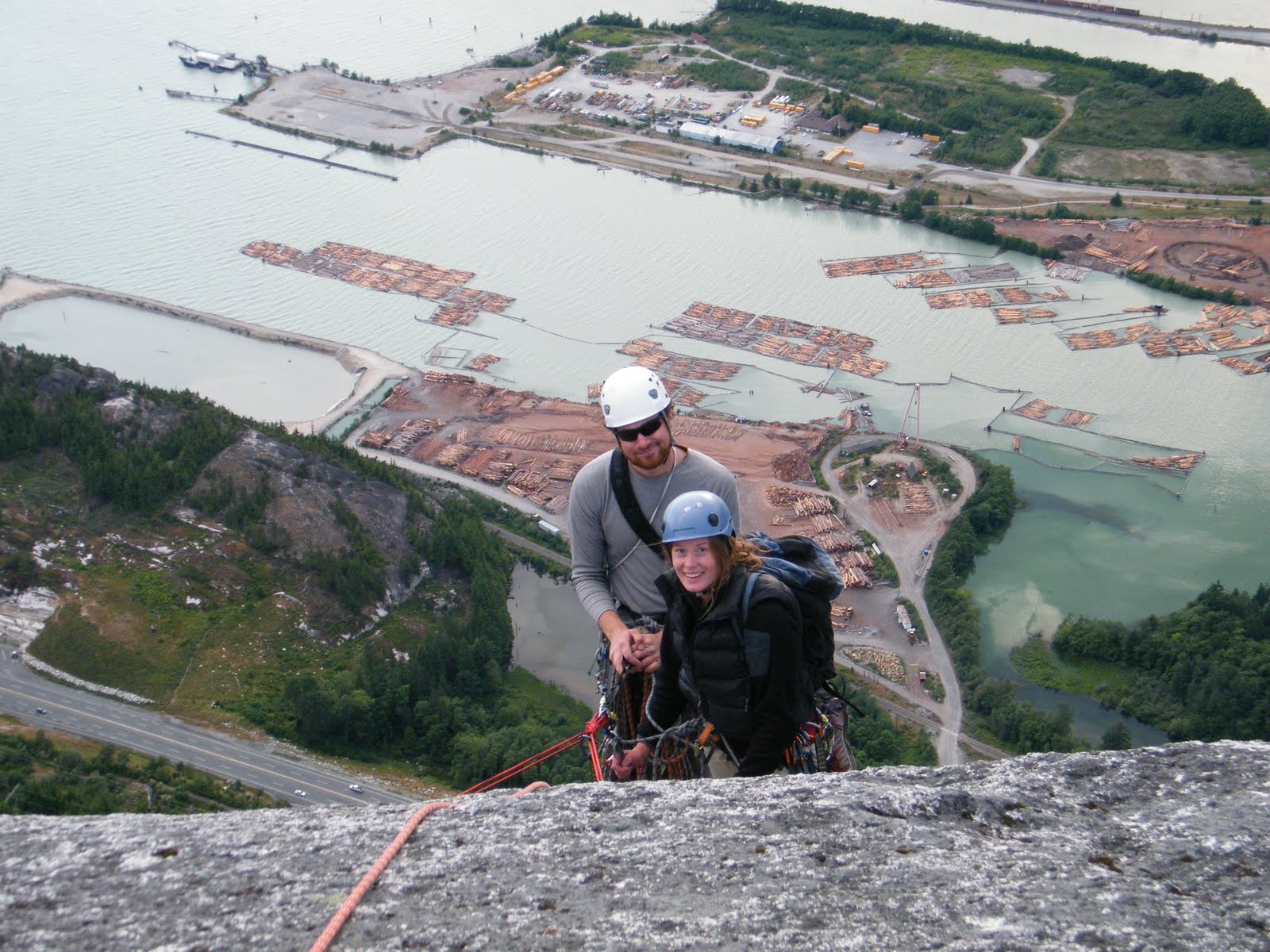
So close to the top. After much Thrashing there is just a few meters to scramble to the summit! If you look really close you can see teeny tiny cars down on the sea-to-sky highway.
A few people have been having trouble posting comments... If you don't have some sort of account with igoogle, or blogger then make sure you select either "name/url" (you do not have to provide a URL) or "anonymous". We have changed a few things, so this should work better now! Hope to hear from you!
This past Sunday Paul and I went to Vancouver and were treated to a fantastic dinner with my aunt Cher and a stroll along the sea wall. We had an amazing day and it was great to catch up! It is so great that living out here gives us the opportunity to see the people that we haven't seen for so long. There are still so many other people that we have yet to meet up with and we are really looking forward to the opportunity to be able to see them!
Yesterday Lowell, Paul and myself decided to charge the Stawamus Chief Mountain and complete not only our first full ascent of the face but also the longest climb we have done thus far. We planned to link-up 4 different climbs, The Bottomline, Banana Peel, Boomstick Crack and The Ultimate Everything to create the most number of pitches possible to the summit; 23. Averaging at about 35 meters per pitch and average grade of 5.8 it was bound to be a fun but physically intensive day.
The guys hauled me out of my sleeping bag earlier then I would of liked and we were off to the Apron parking lot for breakfast and to rack-up. Even as a team of three we flew up the first 2 climbs (3 pitches of the Bottomline and 7 for Banana peel) which were fun but relatively easy climbing. Next up was the fantastic Boomstick crack, which I somehow lucked out on getting as my lead (we rotate turns leading so that we can all rest between our leads since they tend to be more mentally and physically challenging then climbing as a second). This pitch was a huge flake (read: chunk of rock that has separated from the main mass of the rock face, but is somehow still suspended there) that you mantled onto (imagine trying to stand up on a fireplace mantel) and then shuffled your way along its impressively sharp edge. Very interesting and certainly a lot of fun. In some parts you could even see all the way through the crack to the face below the flake!
By quarter to 11 we were at the top of the Apron which is characterized by its low angle slab climbing; it stretches out from the vertical walls towering above at about a 40 degree angle (it does vary substantially depending on where you are, so this more an average) sloping down to the road and the ocean below. We felt like we were up high already and we were only half way!
After some rambling though the forest and ooing and aweing over impressively large/overhung/vertical rock faces we found the start of "The Ultimate Everything". Paul was up first as the leader and took on the first difficult pitch of the day; face climbing, with a though-provoking step over an arete (read: outside corner) to a dihedral (read: inside corner... silly climbing slang, eh?). On the next pitch Lowell learned first hand what "runnels" are; smooth water-worn grooves and dishes... The route certainly offered the ultimate assortment of climbing; face climbing up featured dikes (a seam of a different type of rock), friction climbing on rough slab, and even a short (sadly too short) section of crack climbing.
Unfortunately the only pitch we were not fond of was the last; it was likely a combination of mental and physical fatigue, not eating or drinking enough for our activity level (so hard to stay on top of that) and the fact that it was the crux pitch, but we all really struggled up the final 30 meters. I think we were all a bit worried that if we didn't get up it we would have a long and difficult time trying to find an alternative way to get down, however Paul was the hero of the day and thrashed his way to the summit then hauled Lowell and I up behind him. It was 8pm.
It felt so incredible to have climbed to the summit of the Chief and it will be certainly an achievement that all of us will remember. The hiking back down the backside and to the car took us till 10:20 making it a 14 hour day car-to-car. It was a fantastic day and we were all so tired by the end of it that we must of looked like we had been drinking; stumbling, weaving and shuffling around in the parking lot as we pulled off our gear.
I am afraid that there are no photos for me to post right now (we were using Lowell's camera) but will post them as soon as we get a hold of some copies ourselves! For now, just imagine our harness-framed bums going up a huge chunk of rock....
Just so you've got some thing to look at , here are a few random photos:
Shy trying to blend in in Whistler Giant Slugs!!! Since we took this we have found even bigger slugs... many times spotted slimming their way up the side of the tent...
Once you get to the anchor at the top of a pitch you need do something with all your stuff (extra ropes, bags, gear... ) so it ends up hanging off the rock in an organized mess.


 The leopard spots are coming back!
  The leopard spots are coming back!